Map of Port of Spain Trinidad Value Guide
- Period
- 1930-1940
- Origin
- Trinidad and Tobago
- Materials
- Paper
- Category
- Maps
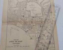
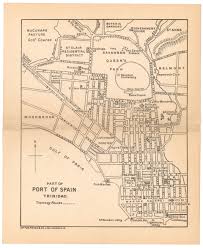
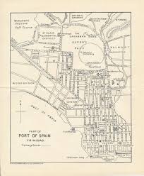
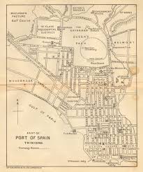
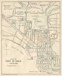
This 1930-1940 map of Port of Spain captures Trinidad's capital during a pivotal era of British colonial development and urban expansion. It serves as a vital historical record of the city's infrastructure and its growing prominence as a major Caribbean maritime hub.
What Is Map of Port of Spain Trinidad Worth?
The typical price range for Map of Port of Spain Trinidad is $75 - $75 based on recent sales. However, values can vary depending on the item's condition, rarity, and other factors such as:
- Physical condition of the paper, specifically the absence of foxing, tears, or significant fading of the ink.
- The level of detail regarding specific landmarks and historical administrative boundaries within the Port of Spain city limits.
- Historical provenance or evidence that the map was used for official navigation or British imperial administration.
- Rarity of the specific edition and the demand for Caribbean cartography from the interwar period.
How to Identify Map of Port of Spain Trinidad?
- Look for specific British colonial administrative markings and era-appropriate typography common in the 1930s.
- Verify the paper stock for authentic mid-20th-century aging, which should show natural oxidation rather than uniform staining.
- Check for the inclusion of key landmarks and street layouts unique to the pre-WWII urban planning of Trinidad and Tobago.
- Examine the printing method to ensure it matches the lithographic or offset techniques used between 1930 and 1940.
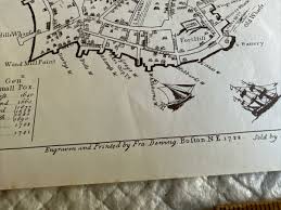
History of Map of Port of Spain Trinidad
Port of Spain, the capital of Trinidad and Tobago, has a rich history as a major port and cultural hub in the Caribbean. This map likely dates from a period of significant development and British colonial influence, reflecting the urban planning and infrastructure of the time. Such maps were crucial for navigation, administration, and illustrating the growing importance of the city within the British Empire and the wider Caribbean.
Shop Similar
Port of Spain Trinidad Map Plate Drawing Vintage T…
etsy.com · $11
Port of Spain, Trinidad and Tobago 1939 – WardMaps…
wardmaps.com · $15
Vintage Map The Town of Boston Mass 1722 Captain J…
ebay.com · $20
1931 Port of Spain Trinidad & Tobago Antique Map -…
etsy.com · $22
Part of Port of Spain, Trinidad by Sifton Praed: (…
abebooks.com · $95
PORT OF SPAIN. Vintage map. Trinidad. West Indies.…
ebay.com
Related Items


Have an antique to identify?
Get an instant AI appraisal with values, history, and market insights.
Download for iPhone