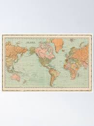
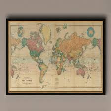
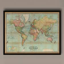
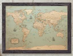
Mercator Projection World Map Value Guide
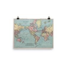
- Period
- 1895-1900
- Origin
- Germany
- Materials
- Paper, Wood, Ink
- Category
- World map
This late 19th-century German world map utilizes the iconic Mercator projection, a revolutionary cartographic method first introduced in 1569 for nautical navigation. Produced between 1895 and 1900, this piece reflects the era's peak colonial geography and the enduring legacy of Gerardus Mercator's straight-line bearing system.
What Is Mercator Projection World Map Worth?
The typical price range for Mercator Projection World Map is $150 - $200 based on recent sales. However, values can vary depending on the item's condition, rarity, and other factors such as:
- The physical condition of the paper, specifically the presence of foxing, tears, or significant fading of the ink.
- The aesthetic quality and historical accuracy of the original wood frame from the 1895-1900 period.
- The level of detail in the German cartography, including specific colonial borders and maritime routes depicted.
- Rarity of the specific German publisher or map series from this five-year production window.
How to Identify Mercator Projection World Map?
- Look for German-language cartographic labels and publishing marks consistent with late 19th-century printing.
- Verify the characteristic Mercator distortion where landmasses like Greenland appear disproportionately large compared to Africa.
- Examine the paper for authentic age-related toning and the specific ink quality used in German lithography circa 1895.
- Check the frame construction for period-appropriate wood and mounting techniques used in the late 1800s.
History of Mercator Projection World Map
Gerardus Mercator introduced his world map in 1569, revolutionizing navigation with its unique projection. This projection became the standard for nautical charts due to its ability to represent lines of constant true bearing as straight segments. While it distorts landmass sizes, especially near the poles, its utility for seafaring ensured its widespread adoption and lasting legacy in cartography.
Shop Similar
1904 Vintage World Map" Poster for Sale by gin-nek…
redbubble.com · $12
Antique World Map Print: 1898 Mercator Projection …
etsy.com · $20
Vintage World Map Print: 1914 Mercator Projection …
etsy.com · $20
Vintage World Map (1912) Poster Meractor's Project…
ebay.com · $28
World Map Poster - Rustic Style – KR Maps
krmaps.com · $40
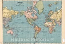
Map : World 1895, Map of the world on Mercators Pr…
historicpictoric.com · $50
Related Items


Have an antique to identify?
Get an instant AI appraisal with values, history, and market insights.
Download for iPhone