WWII Silk Escape Map Value Guide
- Period
- 1940-1945
- Origin
- United States
- Materials
- Silk
- Category
- Military collectibles
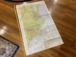
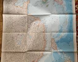
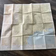
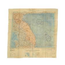
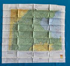
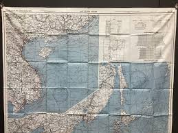
This United States Army Air Forces silk escape and evasion map is a vital artifact from the 1940-1945 era, specifically designed for airmen operating over East Asia. These maps are highly collectible because they represent the ingenuity of Allied survival gear, offering a silent, waterproof alternative to paper that could be easily concealed in a flight suit.
What Is WWII Silk Escape Map Worth?
The typical price range for WWII Silk Escape Map is $500 - $550 based on recent sales. However, values can vary depending on the item's condition, rarity, and other factors such as:
- The current market value for this East Asia theater map is estimated between $500 and $550.
- Physical condition is paramount; maps free of foxing, fraying, or heavy staining command the highest prices.
- The specific geographical region depicted can influence rarity, with certain East Asian flight paths being more sought after by collectors.
- Historical provenance or evidence that the map was issued to a specific pilot can significantly increase its valuation.
How to Identify WWII Silk Escape Map?
- Verify the material is genuine silk or early rayon, which feels smooth and lacks the crisp rustle of paper.
- Check for specific East Asia geographical markings and military-grade printing consistent with 1940s USAAF standards.
- Look for finished or heat-sealed edges designed to prevent fraying during rugged field use behind enemy lines.
- Examine the ink quality for high-contrast topographical details that remain legible despite the fabric's texture.
History of WWII Silk Escape Map
During World War II, silk maps were a vital piece of equipment for Allied airmen. Designed to be lightweight, durable, silent when unfolded, and resistant to water, these maps could be easily concealed and were essential for pilots and aircrew who might be shot down behind enemy lines. They provided critical navigational information, allowing soldiers to evade capture and find their way to safety. These maps were often printed on silk or rayon to prevent rustling noise that paper maps would make, which could betray a soldier's position. Many different versions existed, tailored to specific operational areas.
Shop Similar
Vintage Map of the China Coast and Korea - Nationa…
etsy.com · $21
1945 Aeronautical Chart 25DF Restricted Folded Tex…
ebay.com · $35
ORIGINAL WWII USN PILOT NORFOLK VIRGINIA AERONAUTI…
ebay.com · $75
Original U.S. WWII Army Air Forces Cloth “Silk” Es…
ima-usa.com · $500
GROUP OF EIGHT ARMY AIR FORCES (AAF) WWII ESCAPE A…
abebooks.com · $800
1943 WWII US Military Map Silk Army Map of Japan a…
ebay.com
Related Items

Have an antique to identify?
Get an instant AI appraisal with values, history, and market insights.
Download for iPhone