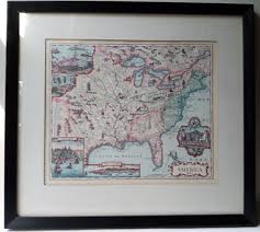
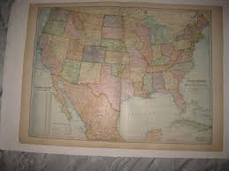
Map of North America Value Guide
- Period
- 1688-1700
- Origin
- France
- Materials
- Paper, ink, wood, glass
- Category
- Map
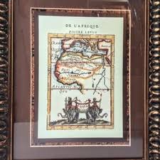
This late 17th-century French map offers a fascinating glimpse into the era of intense European exploration and early colonial expansion in North America. Produced between 1688 and 1700, it showcases the evolving geographical knowledge of the time, often blending scientific observation with decorative mythological elements and indigenous figures.
What Is Map of North America Worth?
The typical price range for Map of North America is $500 - $600 based on recent sales. However, values can vary depending on the item's condition, rarity, and other factors such as:
- The physical condition of the paper, including the presence of foxing, tears, or significant fading of the ink.
- The rarity and reputation of the specific French cartographer or engraver responsible for the plate.
- The inclusion of highly sought-after decorative elements like elaborate cartouches or mythological creatures.
- The quality and age of the frame, wood, and glass used to preserve the document.
How to Identify Map of North America?
- Look for French cartographic signatures or publishing marks common to the 1688-1700 period.
- Examine the paper for chain lines and watermarks consistent with 17th-century European papermaking.
- Identify specific geographical inaccuracies of the era, such as the depiction of California as an island or undefined northern territories.
- Check for hand-colored ink details and decorative vignettes featuring indigenous people or mythological sea creatures.
History of Map of North America
This map likely dates back to a period of intense European exploration and colonization of North America. Maps from this era are invaluable historical documents, showcasing the evolving geographical knowledge, political boundaries, and artistic styles of cartographers as they attempted to chart new worlds. Such maps often include decorative elements, mythological creatures, and indigenous figures, reflecting the prevailing worldview and limited understanding of the continent's interior.
Shop Similar

New Military Map of the US; Forts, Posts & Divisio…
etsy.com · $30
18x16.25" Black Framed-Matted AMERICA 1690 based o…
ebay.com · $37

Framed Antique Original Map "Map of Southern State…
ebay.com · $80
Texas Cattle Trail Map Canvas Print — Wall Art Gia…
wallartgiant.com · $129
Sold at Auction: Antique 1862 Map of the Confedera…
invaluable.com · $225
Lot - Framed Map Province of Mississippi
bssauction.com · $550
Related Items


Have an antique to identify?
Get an instant AI appraisal with values, history, and market insights.
Download for iPhone