John Ogilby Road Map Value Guide
- Period
- 1675
- Origin
- Great Britain
- Materials
- Engraved paper, hand-colored
- Category
- Map
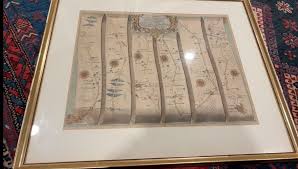
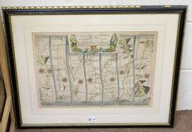
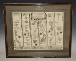
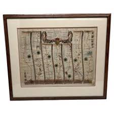
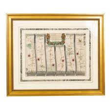
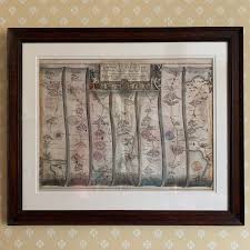
John Ogilby's 1675 'Britannia' revolutionized cartography as the first comprehensive road atlas of England and Wales. These maps are highly collectible for being the first to implement the standard scale of one inch to one mile and the innovative strip-map format.
What Is John Ogilby Road Map Worth?
The typical price range for John Ogilby Road Map is $700 - $850 based on recent sales. However, values can vary depending on the item's condition, rarity, and other factors such as:
- The presence and quality of hand-coloring can significantly increase the market price.
- Physical condition, including the presence of original margins and lack of foxing or tears, is critical for the $700-$850 range.
- The specific route depicted; maps showing major historical thoroughfares or popular cities often command higher premiums.
- Authenticity of the engraving, ensuring it is a 17th-century original rather than a later reproduction.
How to Identify John Ogilby Road Map?
- Verify the 1675 publication date, which marks the first edition of the Britannia atlas.
- Look for the distinct 'strip' layout, which displays the route as a continuous vertical progression across several columns.
- Check for the characteristic 17th-century copperplate engraving marks and period-appropriate paper texture.
- Examine the map for the specific one inch to one mile scale notation, a hallmark of Ogilby's work.
History of John Ogilby Road Map
John Ogilby was a Scottish cartographer, best known for his 'Britannia', published in 1675. This work was the first comprehensive road atlas of England and Wales, and a monumental achievement in cartography. Ogilby's maps were innovative for their time, being the first to use a standard scale of one inch to one mile, and for depicting roads in strip form, showing the continuous route from one town to another. His work became the standard reference for travelers and cartographers for over a century.
Shop Similar
Lot 482 - Ogilby (John). Three strip road maps. ci…
dominicwinter.co.uk · £100
The Continuation of the Road from Chester to Cardi…
abebooks.com · $138
Antique 1700'sJohn Ogilby Road Map from Atlas Road…
ebay.com · $299
John Ogilby Oxford to Salisbury Road Map #83 Circa…
1stdibs.com · $716
Road Maps of England by John Ogilby - A Pair | Cha…
chairish.com · $1850
John Ogilby (1600–1676), England Antique Late 17th…
etsy.com
Related Items


Have an antique to identify?
Get an instant AI appraisal with values, history, and market insights.
Download for iPhone